Doka-La stand-off: Legal status, a way out, and urgent steps for Bhutan
Summary
In this article, we discuss the legal status of the India-Bhutan-China tri-junction region, and suggest a resolution that does not need any side to "eat its words" or give up its legitimate interests. We suggest some steps that Bhutan should urgently take to secure its control over its territory. We also have some advice for Doval's upcoming trip to Beijing.
The Location
There has been some confusion in the media about names and locations. Hence we shall first clarify the setting.
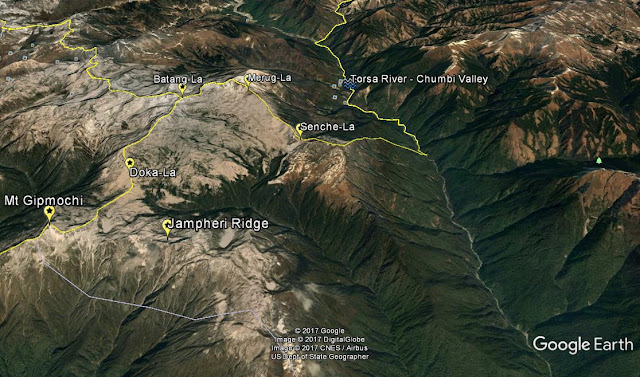
The Torsa river (also called the Amo Chhu in Tibet) flows south from Tibet, through the Chumbi valley. There is a section of the Torsa dividing Bhutan on its east from Tibet on its west. Sikkim lies further west, beyond the ridge dividing the Teesta watershed from that of the Torsa. Further downstream, the Torsa enters Bhutan. The stand-off is taking place near the tri-junction point of India, Bhutan and China. The location is pictured in the following Google Earth view. The yellow lines shown depict the boundaries as claimed by Bhutan.
The Torsa river (also called the Amo Chhu in Tibet) flows south from Tibet, through the Chumbi valley. There is a section of the Torsa dividing Bhutan on its east from Tibet on its west. Sikkim lies further west, beyond the ridge dividing the Teesta watershed from that of the Torsa. Further downstream, the Torsa enters Bhutan. The stand-off is taking place near the tri-junction point of India, Bhutan and China. The location is pictured in the following Google Earth view. The yellow lines shown depict the boundaries as claimed by Bhutan.

As per Bhutan, this India-Bhutan-China tri-junction is at Batang-La. The Chinese are claiming that the tri-junction is at Mt Gipmochi. Between Batang-La and Mt Gipmochi, is the Doka-La pass, where there is an Indian post. The Doka-La plateau is the relatively flat area to the east of the ridge between Batang-La and Mt Gipmochi, bounded by the polygon with points at Batang-La, Merug-La, Sinche-La and Doka-La. The Jampheri ridge extends west and then south-west from Mt Gipmochi to the Chumbi valley below. The Chinese have already constructed a track from Chumbi Valley, entering the Doka-La plateau from the north at Sinche-La. This track has two branches, one of which turns back and exits the plateau at Merug-La, and the other which terminates about 100 m from the Indian post at Doka-La. (This geographical information is sourced from this post.) Doka-La is about 2.5 km north of the Jampheri ridge. The Royal Bhutanese Army maintains a camp on the Jampheri ridge [1]. The Jampheri ridge overlooks the North Bengal plains in the crucial Siliguri corridor linking the North-East to the rest of India, and is thus considered by India to be crucial for its security.
Reportedly, the present crisis started when the Chinese brought earth-moving equipment to the Doka-La plateau, and sought to extend the track from Doka La towards the Jampheri ridge [1].
Reportedly, the present crisis started when the Chinese brought earth-moving equipment to the Doka-La plateau, and sought to extend the track from Doka La towards the Jampheri ridge [1].
The Legal Position
There have been several agreements between the involved parties:
- In 1890, there was an agreement between China and the British over the boundary between Sikkim and Tibet, from the tri-junction with Bhutan to the tri-junction with Nepal, based on watershed [2]. Areas draining into the Teesta are on the Sikkim side, and those draining into the Torsa are on the Tibetan side. This treaty identifies Mt Gipmochi as the Sikkim-Bhutan-Tibet tri-junction. This agreement was made by Britain on behalf of India, was inherited by independent India as per the Indian Independence (International Arrangement) Order notified by Secretariat of the Governor-General on 14 August, 1947. It is important to note that Bhutan is not a signatory to this agreement, and is thus not bound by it. This agreement was initially rejected by Tibet, but was agreed to by it in 1904. [Text of agreement]
- There are two agreements, in 1988 and in 1998, between Bhutan and China which require China to maintain the status quo as before March 1959, pending a final boundary settlement. [1]
- There is a trilateral agreement between India, China and Bhutan, signed in 2012, which states that the three nations will together decide on the boundaries at the tri-junction. [3]
From these agreements, the following facts emerge:
- Bhutan is not bound by any agreement to accept Mt Gipmochi as the tri-junction point. Indeed, it's position is that Batang-La is the tri-junction.
- Unilateral Chinese actions to extend and improve its tracks on the Doka-La plateau are in contravention of its bilateral and trilateral agreements with India and Bhutan. Bhutan has formally protested in a written demarche issued to the Chinese embassy in New Delhi.
- Bhutan has a general right as a sovereign nation to seek Indian assistance in securing its interests.
- Even if we consider the maximal Chinese claim, with Mt Gipmochi as the tri-junction, Bhutan has a right to be on the Jampheri ridge (which India considers as crucial to its interests). Indeed, the Royal Bhutan Army is already maintaining a camp there.
Defusing the stand-off
The atmosphere has unfortunately been vitiated by the aggressive statements emanating from the Chinese. They have refused to negotiate with India, and have demanded a unilateral Indian withdrawal. As far as I know, the Chinese have not, as yet, refused to talk with Bhutan over the issue, and this is what could provide a way out.
The Bhutanese army already has an army camp on the Jampheri ridge, and it should urgently strengthen its position along this ridge, for some 5 or 6 km from Mt Gipmochi towards the Chumbi valley below. Possibly, there could be a post manned by two or three soldiers, every 200 meters or so. Bhutan is entirely within its rights to be on this ridge even under the maximalist Chinese scenario.
At the same time Bhutan should negotiate with the Chinese a code of conduct in the Doka-La area. The Chinese should refrain from coming closer than say 1 km to the established Bhutanese positions on the Jampheri ridge, and also refrain from undertaking any infrastructure work within say 2 km from these positions. This would be an operational understanding with the Chinese, pending the final resolution of disagreement over the tri-junction point. This understanding should not prejudice Bhutan's position that the tri-junction is at Batang-La. If the Bhutanese are successful in obtaining such commitments from the Chinese, then the Indian Army would be in a position to withdraw unilaterally, and the stand-off would end without any side having to "eat its words" or give up its legitimate interests.
In my view, the Chinese would be able to reach such an understanding with the Bhutanese, provided they are not driven by aggressive intentions to dominate the Jampheri ridge. Even if they refuse, the Bhutanese position would be strengthened by creating a robust presence on the Jampheri ridge, and the threat to the Siliguri corridor would also be mitigated thereby. Hopefully, the Chinese have the wisdom to realize that they have much more to lose by unreasonable behavior.
Given the 1890 agreement, it is somewhat awkward for India to claim that the tri-junction is at Batang-La. Such a claim can legitimately be made by the Bhutanese, on whom the 1890 agreement is not binding. This is something that Mr Ajit Doval could keep in mind, when he visits Beijing on 27th July 2017 for the meeting of BRICS National Security Advisors.
It can be expected that the Chinese will argue that having crossed the 1890 line, Indian personnel are in territory that India has already recognized as being part of Tibet. India can certainly support the Bhutanese army presence on Jampheri ridge from near Mt Gipmochi. Indian personnel can also legally operate on the Jampheri ridge, on invitation of the Bhutanese. The Bhutanese can additionally establish their own supply routes to Jampheri ridge from Chumbi Valley or from Tendu (which is to the south of Jampheri ridge). However, it is best if Indian personnel can avoid operating on the other side of the 1890 line. This restriction does not apply to the Bhutanese Army, as the 1890 agreement does not apply to them. In fact, it would be desirable for the Bhutanese Army to regularly patrol the plateau area from their base on the Jampheri ridge. They could even do some road-building of their own, from the Jampheri ridge northwards to Doka-La and beyond.
If the Chinese refuse to reach an understanding with the Bhutanese on a code of conduct for the Doka-La area, the stand-off situation may have to continue. Nevertheless, it would be best if Indian Army personnel were to withdraw, in a phased manner, to the west of the 1890 line, with the Bhutanese Army taking their place. India should do everything possible to build Bhutanese capabilities so that they can take on this role.
To make the Jampheri ridge easily accessible, it may be possible to establish a ropeway to it from the point marked "Jampheri Base" in the Google Earth view below. The ridge itself is over 500 meters broad, and thus affords ample space for the Bhutanese Army. There should be no difficulty in maintaining a robust presence there round the year.

Other steps that Bhutan urgently needs
As the following map shows, the Chinese are claiming a large contiguous section of territory that includes the tri-junction area [4].

The Chinese have already built roads in the northern-most valley of western Bhutan. See e.g. placemark RC in the Google Earth view below. (This and all other placemarks in the Google Earth view below may be viewed in a Google map here.) The Torsa Strict Nature Reserve is an almost completely uninhabited 644 sq km area that includes valleys V1 and V2. There do not appear to be any Bhutanese roads in this area, and Bhutanese control seems to be precarious.

Steps that Bhutan could urgently take to strengthen their position include:
- Raise the civilian population in valleys V1 and V2. There are already some (hopefully Bhutanese) houses (see H1, H2) in valley V1. More settlement is needed.
- Start tourist activity in Torsa Strict Nature Reserve. Permanent accommodation for support staff is needed. Build helipads and start regular transportation services.
- Build access roads into valleys V1 and V2 from Damthang, about 10-15 km towards the east.
- Have the Bhutanese Army patrol ridge line RL to prevent further incursions.
- If possible build an access road on the east bank of the Torsa river to the lower ends of valleys V1 and V2.
Conclusion
It should be clear from the above discussion that the role of Bhutan is central. It would difficult for India to help Bhutan if it did not seek help, and actively participate in defending its own interests.
From India's point-of-view, the biggest problem with China is China's financial, military and diplomatic support to the rogue Pakistani Military-Jihadi complex. If India seeks to respond, there are a variety of options. However, my view is that on Tibet-related issues, there is not much that can practically be accomplished. It would be much better to focus on the trade relationship, which is heavily weighted in favour of China, and is affecting India's domestic industry. Furthermore, several nations in the region - e.g. Vietnam, South Korea, Taiwan, Japan - have security concerns and territorial issues with China. Such nations would need to collaborate and help each other strengthen their defensive capabilities. India's unilateral moratorium on nuclear testing should also be reviewed. Needless to say, we hope that adversarial situations can be avoided, and that all will show due respect for each other's legitimate concerns.
Sources:
[1] China’s Growing Tendency to Encroach - http://eptoday.com/chinas-growing-tendency-to-encroach/
[2] How the Convention of 1890 is a treaty of convenience for China - http://www.dailyo.in/politics/china-convention-of-1890-indo-china-border-doklam/story/1/18252.html
[3] China in unilateral bid to change status of Dokalam: Sushma Swaraj - http://www.livemint.com/Politics/zUthboZxHJrXQSRMlE8sWO/Sushma-Swaraj-snubs-China-says-all-nations-with-India-on-Do.html
[4] China in unilateral bid to change status of Dokalam: Sushma Swaraj - http://indiatoday.intoday.in/story/doklam-standoff-china-india-bhutan/1/1002906.html
--------------------------------------------------
Readers are welcome to leave their comments below, and/or contact the author at bharatdharma7@gmail.com
Comments
Post a Comment